
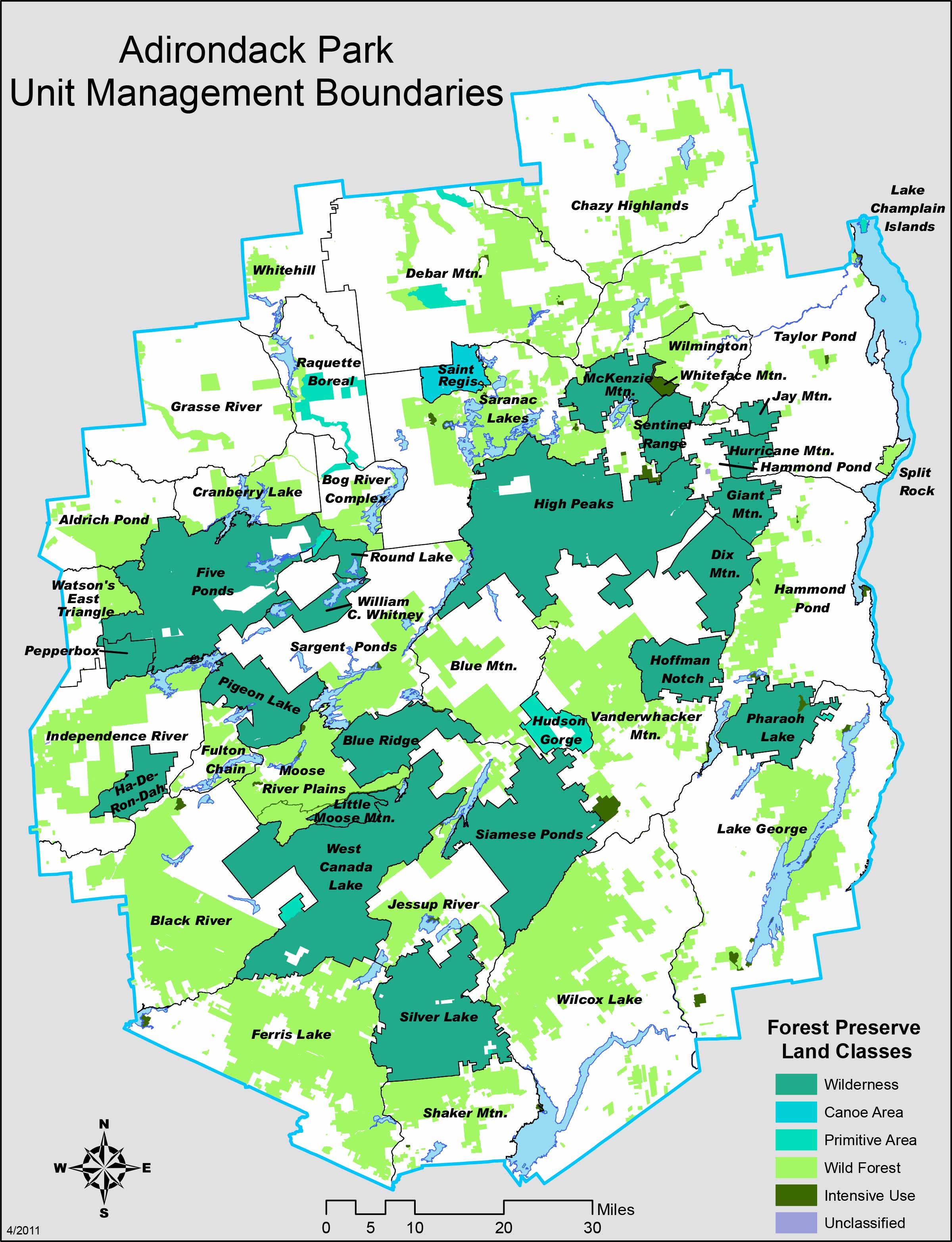
This map shows all of the designated wilderness areas, wild forest areas, primitive areas, and canoe areas. Click any of these areas to see a brief description.
WILDERNESS AREAS
Blue Ridge
This wilderness area is located in the towns of Arietta, Lake Pleasant and Indian Lake in Hamilton County. It is roughly bounded on the north by Route 28; on the east by Route 28 and private lands immediately west of this route; on the south by private lands immediately north and west of Cedar River Flow; and on the west by the Lake Kora and Sagamore Lake properties and the South Inlet of Raquette Lake.
The area is dominated by Blue Ridge, a height of land ranging from 2,700 to 3,497 feet in elevation and running in a general east-west direction for a distance of more than six miles. On the lower north slopes of the ridge there are a number of attractive little trout ponds with foot trails leading to them from Route 28. The forest cover is typical mixed hardwood-softwood types with the higher elevations predominantly covered with spruce and balsam.
The Blue Ridge wilderness is easily accessible along most of its perimeter. A portion of the Northville-Lake Placid foot trail runs from the south boundary northward to the vicinity of Stephens Pond and Lake Durant. In all there are 15 miles of foot trails, 3 lean-tos and 19 bodies of water.
Dix Mountain
This area is in the towns of Elizabethtown, Keene and North Hudson, Essex County. It is roughly bounded on the north by Route 73, on the east by the Adirondack Northway, on the south by Blue Ridge Road and on the west by Elk Lake and AuSable Club lands.
The terrain is rough, rocky and mountainous, with several of the mountain tops exceeding 4,000 feet. Twelve small ponds, with a total surface area of about 115 acres, lie in the wilderness. Vertical cliffs of considerable height are common, particularly in the northern and eastern parts. Most of the mountains do not have any marked, maintained foot trails leading to their summits, even though excellent views are features of this area. The steep, rugged terrain, characteristic of nearly the whole area, has been responsible for the region’s retaining a wilderness atmosphere.
Some of the most severe and extensive forest fires of the Adirondacks occurred in this area during a prolonged drought period in 1903. As a result, the tops and upper slopes of the mountains not only lost their forest cover but the humus was also consumed and the mineral soil eroded down to bare rock.
The present forest cover consists chiefly of pole-size yellow birch, aspen and stunted balsam at the higher elevations with mixed hardwoods and softwoods on the better soils at lower elevations. Some of the mountains, such as Dix, South Dix and McComb, have had small landslides in recent years which occur mostly on the near vertical north slopes. This has left a series of prominent, bare rock scars on the upper slopes.
Their are four trailless peaks in the area – South Dix, East Dix, Hough and McComb – that are over 4,000 feet in elevation. The use of areas such as this by the public, without marked and maintained foot trails, is high, as indicated by the registers that are located on the peaks.
The Adirondack Trail Improvement Society, with headquarters at St. Huberts, maintains a system of foot trails in the northern and northwestern part of the area, with approval of the New York State DEC. Their trails extend to such mountain tops as Round Top, Noonmark, Bear Den, Dial, Nippletop, Colvin, Blake and Pinnacle.
Five Ponds
This wilderness is located in the towns of Fine and Clifton in St. Lawrence County, the town of Webb in Herkimer County and the town of Long Lake in Hamilton County. It is bounded on the north by Cranberry Lake, a portion of the Oswegatchie River, the road leading to Inlet and private lands; on the east by the Colton town line and private lands in the vicinity of Gull Lake, a road leading to Gull Lake and the Remsen to Lake Placid railroad; on the south by Stillwater Reservoir; on the southwest by the Pepperbox Wilderness Area and on the west by private lands and the Aldrich Pond Wild Forest.
The terrain is low, rolling and interspersed with many small ponds. Swamp areas and small brooks are numerous. The forest cover varies from pole-size hardwoods in the sections that were heavily logged and burned more than forty years ago to virgin pine and spruce stands.
This is one of the few locations in the northeastern United States where stands of virgin timber can be found. When early logging was in progress and the Oswegatchie River carried the softwood logs downstream to the sawmills, it was found to be impractical to haul the huge logs by horse and oxen from the Five Ponds area out to the landing on Wolf Creek, so that section was not logged. The old growth pine and red spruce stand on the esker between Big Five, Little Five and Big Shallow, Little Shallow and Washbowl ponds is an example of this virgin timber. The pure pine stand at Pine Ridge along the Oswegatchie is another well known spot where examples of original growth timber may be seen.
In addition to these spots, other points of interest to the hiker, camper and fisherman are: High Falls on the Oswegatchie River; Alder Bed Flow on the Middle Branch of the Oswegatchie River; Cat Mountain; “The Plains;” and the numerous clear, spring-fed ponds, most of which support brook trout. The Oswegatchie River was long considered the top brook trout stream in the state, with catches of three to four pound brook trout common during the summer months. This distinction was lost when perch, apparently introduced accidentally or otherwise into Cranberry Lake several years ago, virtually eliminated the brook trout population. At the present time, the area is popular with hunters and fishermen who frequent the interior ponds.
The Oswegatchie is a fine canoeing stream and is used as such to reach interior wilderness points of interest. In 1975 it was classified as a wild river by the Wild, Scenic and Recreational Rivers Act, and in 1977 was closed to motorboat use.
The Five Ponds area is accessible to the public from the north and also from the south if one has a boat or canoe, from the east in the Lake Lila Primitive Area and the Remsen to Lake Placid railroad. The area can also be reached from the southwest via the Raven Lake primitive corridor, and from the east, by boat or canoe, via the newly acquired Bog River/Low’s Lake tract. The western boundary in Herkimer County is accessible from the Bear Pond road in the Aldrich Pond Wild Forest.
Giant Mountain
This area lies in Essex County, in the towns of Elizabethtown and Keene, and is roughly bounded by Route 9N on the north, by Route 73 on the west and south and Route 9 on the east.
During 1903 one of the major forest fires of the Adirondacks swept over the greater part of this area, burning the topsoil down to bare rock and leaving the two dominant mountains of this area, Giant and Rocky Peak Ridge, practically bald. A few pockets on the lower slopes escaped the intense burn and are easily distinguishable as they now contain old growth white-pine and hemlock stands with some mixed hardwoods.
The topography of the area is steep and rocky with a considerable number of vertical or near vertical cliffs. A number of landslides have occurred on the west side of Giant Mountain, exposing bare rock. Numerous small brooks cascade down from the upper slopes.
From the eastern boundary of Route 9, a few miles south of Elizabethtown, to the top of Giant Mountain, a horizontal distance of about six miles, the elevation change is about 4,000 feet, which represents the greatest differential in elevation per horizontal mile of any wilderness area.
Only two small ponds are in the area, but each one is rather unique because of its location and attractiveness. Giant’s Washbowl lies in a small depression near the 2,300 foot level on the lower south slope of Giant Mountain and has a surface area of about five acres. The lovely little tarn near the summit of Rocky Peak Ridge has been referred to locally by a number of different names, but a sign appeared in the early ’70’s with the name “Lake Marie Louise.” It is reminiscent of the subalpine lakes of the western United States. The sharp col, referred to as Gusty Gap, between Giant Mountain and Rocky Peak Ridge is another attractive feature of the area.
Many small brooks cascade down from the upper slopes and one in particular, Roaring Brook, has a scenic waterfall which may be seen from Route 73, about one mile north of Chapel Pond. A number of similar brooks in the area provide scenic spots as well as trout fishing pools.
Access to the state lands around the perimeter is excellent, with trailheads available on each of the four sides.
HA-DE-RON-DAH
This area is located in the town of Webb, Herkimer County, and the Town of Greig, Lewis County. It is bounded on the north by private lands in the vicinity of North Pond, Hitchcock Pond, Moose Pond and the headwaters of the Independence River; on the east by private lands along the Remsen to Lake Placid railroad right-of-way; on the south by private lands along Route 28 and by the wood road leading to the Copper Lake property; and on the west by Pine Creek and a DEC maintained foot trail from Pine Creek to Pine Lake, East Pine Pond, and Big Otter Lake.
The terrain consists of low rolling hills with many beaver meadows and swamps. Although the area is forest covered, extensive forest fire damage in the southern half has resulted in much of it now being covered with brush, pin cherry, aspen and bracken fern.
In the northern half, mixed hardwood and softwood stands of trees relatively small in diameter predominate. The exceptions are the scattered individual white pine trees just north of the former truck trail which were not cut in the last logging operation. Some of these trees exceed 100 feet in height and are more than 40 inches in diameter.
Public access from the north and south is nearly all blocked by private lands. The same is true for most of the eastern and western boundaries except at the state truck trail entrance near Thendara and the Big Otter jeep road from the west.
High Peaks
This is the largest of the wilderness areas and is located in three counties and six towns; the towns of Harrietstown, North Elba, Keene, North Hudson, Newcomb and Long Lake. It is roughly bounded on the north by Route 3, the old Haybridge Road, which runs from Cold Brook to Averyville, the Adirondack Loj property at Heart Lake, the Mount Van Hoevenberg Winter Recreation Center and Route 73 near the Cascade Lakes. Private land to the west of Route 73 forms the eastern boundary. The southern boundary is formed by privately owned lands, including the AuSable Club, Finch Pruyn, National Lead Company and the State University College of Environmental Science and Forestry’s Huntington Wildlife Forest. This wilderness is bounded on the west by Long Lake and the Raquette River.
The topography ranges from small areas of low-lying swampland (e.g., along the Raquette and Saranac Rivers) to the highest point in New York State at the top of Mount Marcy. Although there is a considerable variety of topography, it is predominantly high mountain country. Like the topography, the forest cover also varies from pole-size hardwoods to mature, large diameter hardwood and softwood stands to the spruce-fir of the subalpine region.
The tops of Mount Marcy and Algonquin are above the timberline and a number of other mountain tops are at or close to timberline. The subalpine and alpine vegetation on the tops of these mountains has been of interest to many people, including students of botany, ecology and zoology, as well as recreationists willing to hike to the mountain tops for superb views of the High Peak region and close observation of unique plant associations. Overuse threatens the continued existence of some of these associations.
The range trail, which traverses a series of mountain summits from Mount Marcy to Keene Valley, has long been considered the most rugged and the most scenic trail in the state. This trail traverses eight of the mountain peaks in this area that exceed 4,000 feet in elevation.
The western portions of the area receive substantially less public use than the Mount Marcy region and afford one of the greatest senses of remoteness obtainable in the Adirondacks.
Many crystal-clear streams cascade from the mountain slopes, providing numerous scenic waterfalls, deep pools and brook trout fishing opportunities. Such streams as the Opalescent River, Johns Brook, Klondike Brook, Marcy Brook, Cold River, Moose Creek and Cold Brook are photographers’ favorites. Lake Tear, the source of the Hudson River, lies at about 4,300 feet altitude on a flank of Mount Marcy.
Hoffman Notch
This area lies in the towns of Schroon, North Hudson and Minerva in Essex County. It is bounded on the north by private lands lying south of the Blue Ridge Road and the Sand Pond Mountain tract donated to the state by Finch, Pruyn and Company for fish and wildlife management and silvicultural research and experimentation purposes, on the east by the Adirondack Northway and private lands immediately west of the Northway, on the south by private lands lying north of the Loch Muller Road and on the west by the jeep road and trail that extends from Irishtown along Minerva Stream northward to the Blue Ridge Road near Cheney Pond.
The area is mountainous and rugged with three north-south ridges in excess of 3,000 feet dominating the area: Blue Ridge, Texas Ridge and Washburn Ridge.
The forest cover ranges from second growth hardwoods of sapling and pole-size to nearly solid conifer stands of near mature size at the higher elevations. On some of the better soil, exceptionally large diameter hardwoods occur.
Hurricane Mountain
The 13,784-acre Hurricane Mountain Wilderness is part of the Adirondack Forest Preserve. The majority of the area is comprised of mountainous uplands visible from the nearby towns. Hurricane Mountain, the unit’s namesake, is the most prominent feature of the area. The bare rock 3,678-foot summit provides a 360-degree view that takes in the High Peaks, Lake Champlain and the Green Mountains of Vermont. A 35-foot fire tower is located on the summit.
Jay Mountain
This area lies within the towns of Jay and Lewis in Essex County. It is bounded by the Glen Road on the south and private land boundaries elsewhere except where the road west of Mt. Fay severs an appendage of state lands.
The high and precipitous mountains in this area are generally similar in character to the Hurricane range and require careful management in order to avoid natural resource degradation. The vistas from Jay, Saddlebrook and Slip Mountains make the climb to the vantage points well worthwhile. The AuSable Valley can be seen as well as the Champlain Valley and the High Peaks.
McKenzie Mountain
This area is located in western Essex County in the towns of St. Armand, North Elba and Wilmington. In general, the Saranac River and Franklin Falls Reservoir border on the north; the Wilmington-Franklin Falls road, the Whiteface Mountain Memorial Highway and the west branch of the AuSable River form the eastern boundary; the Saranac Lake-Lake Placid Road, Route 86, forms the southern boundary; and the Saranac River forms the western boundary.
McKenzie Mountain, sometimes referred to as Saddleback, and Moose Mountain, sometimes called St. Armand Mountain, dominate the topographical features of the area.
McKenzie Pond, from which the village of Saranac Lake obtains its water supply, forms part of the boundary on the west side as does Moose Pond, but few ponds are encompassed within the boundaries of this area. Bartlett Pond, lying at about 2,800 feet altitude on the southeast side of McKenzie Mountain, and Loch Bonnie which is at about 2,900 feet altitude on the southeast side of Moose Mountain are, however, in the wilderness.
The area is densely forested with softwoods, with spruce and balsam predominating above the 2,500 foot level and mixed hardwoods and softwoods predominating at the lower elevations.
The attractiveness of the area is enhanced by the excellent views that may be obtained from the top of McKenzie Mountain and Moose Mountain. There are numerous spring-fed brooks, mostly on the north slopes of the area. Lincoln Brook and French Brook, with their tributaries originating high on the northwest slopes of Esther Mountain and Whiteface Mountain, are crystal clear trout streams with many scenic spots along their courses.
The Department of Environmental Conservation maintains a foot trail from the pull-off east of the Saranac Lake Golf Course on Route 86 to the top of McKenzie Mountain. The Lake Placid Shore Owners Association trail over private lands along the west shore of Lake Placid is open to those who obtain the association’s permission to use it. After leaving private land this trail winds its way to the tops of Moose, McKenzie, Tamarac and Colburn Mountains.
Public access to the area is relatively good from all sides.
Pepperbox
The Pepperbox Wilderness lies totally within the town of Webb in Herkimer county. Stillwater Reservoir and the Beaver River Primitive Area form the southern boundary, while the north bank of the West Branch of the Oswegatchie River generally forms the northern boundary. The western boundary is the county line, and the eastern boundary is the Raven Lake Road and the Five Ponds Wilderness Area.
The terrain is generally flat with a few small, rolling hills. Swampland predominates with spruce, fir and red maple. Alder swamps, marsh and beaver flows are also common. The drier sites are vegetated with pole-size northern hardwoods. The entire area appears to have been heavily burned over and logged in the past and is not particularly scenic by usual standards. It is, however, ideally suited for snowshoeing and crosscountry skiing.
Several ponds are found in the area. They are generally of low productivity and some may even be sterile. The area is classed as wilderness because of its remoteness and also due to the extensive wetland ecosystems involved. The flora and fauna associated with moist ecosystems, such as found in the Pepperbox, seem to exhibit more species diversity than any others in the Adirondacks. Birdlife and small mammals are especially abundant. The protection afforded wilderness tracts will insure an outdoor laboratory of significant biological importance.
There is very little human use of the area at present, except for light hunting. Access is moderately difficult because of the distance from public roads and the lack of a trail system. There is little or no demand for a trail system, and this offers an opportunity to retain a portion of the Adirondack landscape in a state that even a purist might call wilderness.
Pharaoh Lake
The Pharaoh Lake Wilderness straddles the Essex-Warren County line in the towns of Ticonderoga, Hague, Horicon and Schroon. The county road along the east shore of Schroon Lake forms the western boundary; to the north, private land and Route 74 form the boundary. The state land boundary forms most of the remaining perimeter except for a stretch of Route 8 on the south.
Pharaoh Lake, an extremely attractive body of water, is one of the largest lakes in the Adirondack Park totally surrounded by forest preserve lands. Due to its configuration, it can provide a wilderness experience to relatively large numbers of people. In addition, the numerous crystal-clear ponds, vistas resulting from rock outcrops and severe fires, and intriguing geographic names such as Grizzle Ocean, Thunderbolt Mountain, Oxshoe Pond and Desolate Brook, make this one of the most appealing of all Adirondack areas.
Fires have burned over most of the region in the past. As a result of this and the dry sites, much of the tree growth is coniferous with some white birch mixed in. The white pine-white birch type along the shores of several of the lakes and ponds adds immeasurably to their attractiveness. Stands of some of the best quality Adirondack hardwoods exist in the covelike pockets of the unburned area in the northeast.
Pharaoh Mountain is the only mountain of much size, although the smaller hills have very steep sides and cliffs, presenting more of an impression of relief than actually exists. There are a total of 48 miles of foot trails, 15 lean-tos and 39 bodies of water.
Pigeon Lake
This area lies in the town of Webb, Herkimer County, and the towns of Long Lake and Inlet in Hamilton County. It is bounded on the north by Stillwater Reservoir and large blocks of private land in the vicinity of Rose Pond, Shingle Shanty Pond and Upper Sister Lake; on the east by a private road from Brandreth Lake to North Point and by Raquette Lake; on the south by private lands along the Uncas Road; and on the west by the Big Moose Road, private lands near Big Moose Lake, Thirsty Pond, Twitchell Lake, Razorback Pond, and the Remsen to Lake Placid railroad tracks.
The terrain consists of low, rolling hills, with the exception of West Mountain near the eastern boundary. There are many brook trout ponds and streams and a considerable expanse of swampland along the courses of Sucker Brook and Beaver Brook.
The forest cover runs to mature or near-mature mixed softwoods and hardwoods, with some dense spruce-balsam types near the summit of West Mountain and in the swamplands. Old growth white pine in the vicinity of Pigeon Lake and a few other places adds to the wilderness atmosphere.
It is easily accessible to the public from the south, southeast and southwest, but to a lesser extent from the west and north because of posted private lands. The chief attractions for the public are the trout ponds, which entice fishermen as well as campers who frequent scenic spots around Cascade Lake, Queer Lake, Constable Pond, Pigeon Lake and Gull Lake. It is also a popular area for hunters during the big game season.
The Department of Environmental Conservation maintains Brown Tract Pond Campground on the southeast perimeter. Motorboats are now banned from operating on Brown Tract Ponds to provide a more compatible situation for canoes and other non-motorized boats utilized by the campers. This site makes a fine jumping-off place for wilderness users.
Round Lake
The 19,500-acre William C. Whitney Wilderness and the 11,430-acre Round Lake Wilderness Area are part of the Adirondack Forest Preserve. The two wildernesses are separated by the Sabattis Road. Combined, the wildernesses comprise more than 30,000 acres of numerous flat, low lying lands adjacent to low, rolling hills with only a few mountain summits exceeding 2,100 feet, including 2,170-foot high Mt. Frederica. Water is the main feature of the wildernesses. There are four larger water bodies – 2,300-acre Little Tupper Lake, 1,400-acre Lake Lila, 740-acre Round Lake and 282-acre Rock Pond; a number of smaller water bodies and many miles of streams connecting them.
Sentinel Range
This area is located in the towns of Wilmington, North Elba and Keene, Essex County. It is bounded by Route 86 on the north, Route 73 on the south, and private lands on the east and west.
The Sentinel Range and its slopes dominate the area and five small ponds are situated near the northern and northwestern boundaries. Sentinel Mountain and the general northeastern quarter of the area are characterized by bare rock outcropping that resulted from forest fires more than a half century ago. The terrain is steep and rugged, with some vertical cliffs facing north and northeast.
The eastern slopes of the area have a hardwood forest that regenerated after the forest fires. There are mixed hardwood and softwood stands, primarily along brooks on the eastern slopes. The remainder of the area has a mixed hardwood-softwood cover with some small pockets of white pine between ledges near the northern boundary.
Good views may be obtained from the top of Sentinel and Pitchoff Mountains, but forest cover restricts the view of Kelburn Mountain, Stewart Mountain, Slide Mountain and Black Mountain. There is an excellent view of the Wilmington Notch-Whiteface Mountain section from a lean-to site on the south side of Copperas Pond.
More than thirty years ago a ski trail was constructed from the west boundary to South Notch, and a lean-to was constructed at the terminus in the Notch. The trail was reported to have been little used for skiing, but is maintained as a foot trail. The lean-to was eliminated because of deterioration and lack of use.
The major portion of the perimeter is readily accessible to the public from highways but has not been as susceptible to penetration as some of the less rugged state land because of its terrain.
There are 5 bodies of water, 14 miles of foot trails and 1 lean-to
Siamese Ponds
The Siamese Ponds area is located in the towns of Lake Pleasant, Wells and Indian Lake in Hamilton County and the towns of Johnsburg and Thurman in Warren County. It is one of the largest wilderness areas, extending about 18 miles from north to south and about 13 miles from east to west at its widest part.
It is roughly bounded by Route 28 on the north; by private land tracts near Thirteenth Lake, Gore Mountain and Bakers Mills and by Route 8 on the east; by Route 8 on the south; and by Route 8, International Paper Company lands and Indian Lake on the west.
The topography consists of relatively low rolling hills with a few mountain summits like Bullhead, Eleventh, Puffer and South Pond Mountains above the 3,000 foot level. In addition, the area contains a large number of beaver meadows and swamps. On most of the higher elevations, except those in severely burned spots, spruce and hemlock predominate, while mixed hardwoods and softwoods cover the remainder of the area.
This area is known for its lovely natural features. Some of the more popular attractions are Thirteenth Lake, Chimney Mountain, Puffer Pond, Siamese Ponds, Augur Falls on the West Branch of the Sacandaga River, and John Pond. Chimney Mountain has ice caves that usually retain snow and ice through the summer months and provide an interesting spot for visitors.
Thirteenth Lake has a small sand beach at the northern end that makes a very desirable spot for picnics, bathing and camping. There are also other desirable camping spots on this lake.
Silver Lake
This area is located in the towns of Lake Pleasant, Benson, Wells and Arietta in Hamilton County and is roughly bounded on the north by Route 8 and private lands near Piseco Lake, Oxbow Lake, Hamilton Lake, Sand Lake and Lake Pleasant; on the east by Route 30; on the south generally by the Hamilton County line; and on the west by Route 10, the West Branch of the Sacandaga and the Piseco Outlet.
The terrain is relatively low with rolling hills and only four mountain tops that exceed 3,000 feet elevation. There is a considerable acreage of conifer swamp as well as some beaver meadows along the streams.
The forest cover is chiefly mixed hardwoods and softwoods with some stands of nearly pure hemlock in large diameter size. In the swamp area along streams and at the higher elevations around the mountain tops, the forest cover runs predominantly to spruce and balsam.
The Northville-Placid Trail has its terminus at the southern edge of the area and runs through the center in a northerly direction, crossing the northern boundary near Piseco Lake. Although this trail has some use by hikers, the foot trail from the vicinity of Hamilton Lake to the top of Hamilton Mountain is a more popular trail.
Silver Lake is the principal attraction near the center of this area, chiefly for brook trout fishermen. Mud lake, Rock Lake and Loomis Pond are also popular trout fishing spots. Big Eddy on the West Branch of the Sacandaga River and Cathead Mountain also attract visitors to the area.
The perimeter of the area is quite accessible to the public except for a few parcels of private, posted land.
West Canada Lake
This wilderness is located in the town of Ohio in Herkimer County and the towns of Morehouse, Arietta, Lake Pleasant and Indian Lake in Hamilton County. It is bounded on the north by the Moose River Plains area and private lands in the vicinity of Little Moose Lake, Squaw Brook, Snowy Mountain and Squaw Mountain; on the east by Route 30, lands of International Paper Company and the Spruce Lake-Piseco Lake trail; on the south by private lands north of Route 8, the South Branch of West Canada Creek and an access road to private lands; on the west by West Canada Creek and private lands east of Honnedaga Lake.
The terrain ranges from swamp flats and rolling hills to steep mountains such as Snowy. Water drains from the area into three basins: the Hudson, the Mohawk and the Black.
Among the area’s chief attributes are its numerous ponds, lakes and streams, most of which support a brook trout population.
The forest cover consists chiefly of mixed hardwood-softwood types with large diameter trees of both types on the more fertile soils. There is also considerable acreage in spruce-balsam swamp and beaver meadows. Among the spots that attract hikers and campers in addition to the previously mentioned lakes are T Lake Falls and T Lake Mountain, West Canada Creek, Panther Mountain, Snowy Mountain and Cedar River.
William C. Whitney
This wilderness area is located in the town of Long Lake, Hamilton County. It is bounded on the east by County Route 10, on the south by lands of Whitney Industries, on the west by private lands owned by International Paper and the Brandreth Park Association, on the northwest by the Remsen to Lake Placid Railroad right-of-way, and on the north by other private land holdings.
The terrain is comprised of lakes, ponds, wetlands, and low forested hills with a few modest mountains ranging as high as 2,297 foot Antediluvian Mountain. The centerpieces of this area are 2,300 acre Little Tupper Lake and 1,400 acre Lake Lila, respectively the seventeenth and twenty-second largest water bodies in the Adirondack Park. This area also includes twelve smaller water bodies, a short section of the Beaver River, pond and lake outlets and numerous other small streams and flows. There are extensive wetland complexes within the area, particularly along the western end of Little Tupper Lake and the southeastern portions of Lake Lila.
The vast expanses of the area are important to many species of mammals and the area abounds with bird life.
The property contains an extensive network of logging roads which provide prime cross-country skiing trails. However, the primary access to the interior of this area is by water. The DEC Little Tupper Lake Headquarters provides the only legal access to Little Tupper Lake, whereas the existing put-in provides canoe access to Lake Lila.
WILD FOREST AREAS
Aldrich Pond
The 26,702 acre Aldrich Pond Wild Forest is located in the Northwestern Adirondacks, southwest of the small hamlet of Star Lake and west of Cranberry Lake. The area does not get as many visitors as other areas, but is popular with those who enjoy primitive camping. There are a few hiking/biking trails and a few bushwhack opportunities.
The most popular destination of Aldrich Pond Wild Forest is Streeter Lake. This lake features a very busy lean to, camping area and sandy beach. Streeter Lake Road has 11 roadside designated primitive campsites along the road as it makes its way toward the lake. The road follows an old railroad grade. It is a seasonal dirt road. Streeter Lake is on the border with the Five Ponds Wilderness. The road is gated at the outlet of Skeeter Lake, so you have to hike the last 0.5 miles to reach the lean to.
Black River
This area includes the state lands primarily in Herkimer County, south of Route 28, north of Route 8 and west of the Adirondack League Club holdings. The Black River flows in a generally east-west direction through the middle of the area.
A considerable number of interior, privately-owned parcels exist to which jeep trails extend from the public highways. Relatively low hills interspersed with small swamp areas covered with second growth hardwoods on the more fertile soils and spruce-fir combinations along water courses are typical in this southwestern corner of the Park. Mohawk Valley population centers such as Rome, Utica and Herkimer are within short driving distance, and big game hunting pressure in the fall season is heavy. The streams attract many trout fishermen to the area. South Lake is a favorite fishing, hunting and boating spot.
Blue Mountain
This area is located in Hamilton and western Essex counties. It is bounded by Route 30 on the west and south, the Hudson River on the east and Route 28N on the north.
The terrain varies from gentle around the easily accessible and popular Rock Lake to extremely steep and rugged in the remote Fishing Brook Range.
The 3,759-foot Blue Mountain dominates the landscape for some distance around, offering wide ranging views in all directions for those willing to make a short but steep hike to the summit from the picturesque hamlet of Blue Mountain Lake. Tirrell Pond nestles to the northeast of Blue Mountain and, due to relatively easy access, affords an excellent opportunity for day use or primitive camping for family groups and novice hikers.
The ridge from East Inlet Mountain to the Fishing Brook Range represents a wild block of forest preserve unbroken for over ten miles except for a crossing of the Northville-Placid trail.
Chazy Highlands
The 48,362 acre Chazy Highlands Wild Forest consists of scattered parcels of state land in the area surrounding Chateaugay and Chazy Lakes. This is the northernmost Adirondack wild forest and there are no state campgrounds located in this rugged area. The most popular hiking destination is the 3830 foot Lyon Mountain and its fire tower. It is part of the ADK Fire Tower Challenge.
Currently there are very few hiking trails in Chazy Highlands Wild Forest besides Lyon Mountain as the state is still looking for public input on the land (May 2013). There is a hiking trail at the Lewis Preserve Wildlife Management Area, which is located in the area.
Cranberry Lake
This area is located in southern St. Lawrence County in the towns of Clifton, Colton and Fine.
It provides a considerable amount of snowmobiling opportunity in the winter in a setting offering the snowmobiler a sense of remoteness.
A public campsite on the northeastern shoreline permits exploration of the interesting flows of Brandy Brook, East Inlet and Sucker Brook. Trails connecting these and several interior brook trout ponds permit fishing, camping and hunting on a variety of wild forest land.
Boreal forest is visible along Route 3 traversing the western tract, where one can glimpse interesting bog and scattered great pines. A short hike into this spruce-fir forest will often reward the birdwatcher with sighting of species normally found only much further north in Canada.
DeBar Mountain
This area is in the northern section of the Park primarily in the towns of Brighton and Duane, Franklin County. The summit of DeBar Mountain once permitted Verplanck Colvin to triangulate Lake Champlain and the St. Lawrence River. It also offers the broadest distant view in the Park of the High Peaks country to the south. Trails traversing the mixed hardwood-softwood forest preserve lead from Meacham Lake Campground on the west and from the DeBar Mountain wildlife management area on the west.
Ferris Lake
This area is located in the southwestern corner of the Park. It consists of those state lands south of Route 8 and the West Canada Lake Wilderness Area and west of Route 10. Both Route 8 and Route 10, as well as the Powley-Piseco Road, provide easy access to the area.
Numerous small ponds, lakes and streams are distributed throughout the area where both trout and pan fist attract fishermen throughout the season. It is also a very popular area with big game hunters.
One of the last old Adirondack dirt roads, extending about 17 miles from Route 10 near Piseco Lake to Stratford, cuts through the approximate center of this large block of forest preserve. It provides the public with motor vehicle access through practically unbroken forest, quite comparable to some of the wilderness areas. Many motorists take advantage of the attractive drive over this old winding dirt road, the like of which has become a rare and vanishing facility in the eastern United States.
Fulton Chain
This unit is located in Herkimer County, town of Webb, Township 8, John Brown’s Tract, Macombs Purchase. It is divided into four main sections by three strips of privately owned lands, one of which includes lands near the Fulton Chain of Lakes. The unit is roughly bordered on the north by the Razorback Pond Outlet, the Pigeon Lake Wilderness Area and private lands adjacent to Silver and Twitchell Lakes; on the east by the Big Moose Road, Pigeon Lake Wilderness Area, private lands near Big Moose Lake and the Village of Eagle Bay; on the south by the Moose River Plains Wild Forest, the South Shore Road and private lands adjacent to the Fulton Chain of Lakes and on the west by private lands and the west boundary of Township 8. The unit also includes DeCamp or Treasure Island, which comprises two small islands of Forest Preserve between the First and Second Lakes of the Fulton Chain. A permanent easement across private lands connects this wild forest to Razorback Pond and the Pigeon Lake Wilderness Area.
This unit has high recreational potential due to its location within short driving distances from the populated Mohawk Valley. Uses include hiking, campting, canoeing, hunting, fishing, horse-back riding, cross country skiing, snowmobiling, and sight-seeing, the latter drawing many visitors to the Rondaxe Mt. Fire Tower during the fall foliage season.
Grasse River
This 1,274 acre unit is located in St. Lawrence County, Town of Clare and borders both the Main (a designeated Study River) and North (a Scenic River) Branches of the Grasse River. The Adirondack Park Blue Line forms the western boundary of the unit. Access to the unit is by means of the Downerville Road from the north and the gated Lampson’s Mill road from the south. The primary points of interest are Lampson Falls and canoeing on the Main Branch of the Grasse River.
Hammond Pond
This area is located in the towns of Crown Point, Moriah, North Hudson and Schroon in Essex County. Bounded by Route 9 on the west and north, it extends south to Paradox Lake, and its eastern and southern boundaries border private lands.
Owl Pate and Hail Mountain provide great distant views, and exceptionally fine overlooks may be had from the many rocky bluffs and ledges dominating the area.
Access is open to hunters and other recreationists from the Tracey Road, North Hudson-Moriah Road and Route 9. The Sharp Bridge public campground offers trail access to East Mill Brook and the interior. Many ponds offer scenic fishing opportunities and have defined but unmarked trails leading from highways. A great variety of flora and fauna reflect an overlap of forest types where beech, birch, maple and hemlock on the cool, northern slopes give way to oak, ash, basswood and pine on the southerly exposures.
Independence River
This western Adirondack area lies in Lewis and Herkimer counties south of the Beaver River and north of Route 28.
A balance of private lands interlaced with forest preserve tracts characterize this area of gentle hills and flat lands.
The sand plain depressions north from Brantingham Lake to the Independence River offer many unique bird and plant life associations.
Numerous bogs and beaver meadows along the drainage of Beaver Meadow Creek and Second, Third and Fourth creeks provide contrasting wildlife habitats. An extensive network of trails, both foot and snowmobile, link Pine Lake, Big Otter Lake and the Independence River with the Stillwater Road in the north.
Jessup River
This area is located in Hamilton County in the towns of Arietta and Lake Pleasant. Bounded on the north by the “saddle” of Indian Lake, this wild forest land extends easterly to lSacandaga Lake and southerly to Piseco.
Access is from Route 30 and the Perkins Clearing road, which traverse the area, and from the Moffitt Beach and Lewey Lake Campgrounds.
Long popular with hunters, trappers and fishermen, the interspersion of private woodlands with state ownership has made this area a top producer of fish and wildlife. The Jessup and Miami Rivers have long been known as good trout producers.
Numerous logging roads and trails are open to foot travel. The Pillsbury Mountain summit, from which a vast view of lakes and forest may be obtained, offers a particularly enjoyable hike.
Lake George
The wild forest tracts of land associated with this well-known section of the Park straddle the Warren-Washington county line. Mountains rising steeply on either side of the lake provide many views of rugged beauty. The area west of the lake is accessible by Routes 9N and 73 while the forest preserve on the east side is accessible from the Pilot Knob and Hulett’s Landing roads.
The Tongue Mountain and Island Pond sections form the base for a varied wildlife resource. The moderating influence of the lake on both sides of this peninisula has produced an oak-pine cover type which is more characteristic of the southern part of the state than of the Adirondacks. Many plant and wildlife species found on Tongue Mountain are rarely found elsewhere in the Park.
The Black Mountain track on the opposite shore is more precipitous. Spruce and hemlock are common, as recreational enjoyment of the area is enhanced by this diversity of plant and animal associations.
Trails connect the lake at Shelving Rock and Black Mountain Point with interior ponds and the summits of Black Mountain and Sleeping Beauty. The latter provides some exceptional views.
Moose River Plains
This area lies between Route 28 and the West Canada Lake Wilderness in Hamilton and Herkimer counties.
The scenic “plains” of the Moose and Red Rivers are well-known areas of interest to the public. These zones of herb and grass vegetation contrast vividly with the overall forested nature of the Park. Other scenic points of interest include the Moose River cliffs, Mitchell Ponds, Lost Ponds, Icehouse and Helldiver Ponds.
The area is unique also in that the Department of Environmental Conservation maintains an extensive road system and provides numerous scattered individual camping sites along this system. This provides a type of outdoor recreation intermediate between that of the developed campground and primitive tent sites. Heavy use of the road system is made in the winter months by snowmobiles, a use that may not be compatible with the wintering deer population and which may therefore require reassessment.
Hunting, fishing, camping and snowmobiling make this one of the truly four-season recreational areas of the Park.
Raquette Boreal Complex
The Raquette Boreal Complex includes nearly 25,000 acres of Adirondack Forest Preserve and 44,300 acres of Conservation Easement Lands located in the northern portion of the Adirondack Park. The complex is located north of State Route 3 and east of State Route 56.
These lands are defined by the flat to gently sloping terrain and the many waterways that traverse them. Wetlands in the area provide expanses of open space that make a visual contrast to the heavily forested setting. Much of the beautiful scenery of the complex can be seen along the waterways.
The Raquette River from the confluence of Dead Creek to Carry Falls Reservoir (13.8 miles), and the Jordan River from the outlet of Marsh Pond to Carry Falls Reservoir (18 miles) are designated Scenic Rivers under the Wild, Scenic and Recreational Rivers Act.
Both the Raquette River Wild Forest and the Raquette-Jordan Boreal Primitive Area contain low elevation boreal forests, an uncommon forest community characterized by coniferous trees consisting mostly of pines, spruces and larches.
Public access to these lands is primarily from Route 56 and Route 3. The main access to the majority of the complex’s Forest Preserve lands and neighboring conservation easement lands is by boat via Carry Falls Reservoir and the boat launches on it shores.
Saranac Lakes
Easily accessible from Route 3 and 30, this southern Franklin County area offers a broad network of streams, lakes and ponds for water-oriented recreation. Boating access sites, camping areas and portages are convenient for the day user and the long distance traveler alike. The Fish Creek Ponds and Rollins Pond campgrounds offer a base camp for some users of the area.
Ampersand Mountain, just south of Route 3 in the High Peaks Wilderness, provides a superb view of this area as a reward for a three-mile hike through majestic stands of hemlock and northern hardwoods.
Sargent Ponds
Easterly of Raquette Lake, lying north of Route 28 and west of Route 30, lies a labyrinth of boreal swamp forest. Much of this great spruce-balsam-white cedar tract borders the Raquette River, Marion River and Boulder Brook.
Known to many canoeists, hunters and fishermen, this wild forest area offers intimate sightings of Adirondack wildlife and bog plants. The trail to Sargent Ponds courses through stands of old growth forest. Many fo the picturesque tall pines along the Marion River may be glimpsed from the highway.
Public campgrounds on Raquette Lake, Forked Lake and Lake Eaton plus the Deerland Road to the Raquette River provide varied access and recreational opportunity to users of this parcel.
Shaker Mountain
This area is located south of the Silver Lake Wilderness between Routes 10 and 30 in Fulton County. It is near the population centers of Albany, Schenectady and Amsterdam, but remains comparatively little used by the public. Most of the area was heavily logged prior to state acquisition and there are a considerable number of old log roads, chiefly in the southern half, where most of the hills are low and gently sloped. These woods trails make comfortable hiking tails that can be enjoyed by all ages.
A number of small ponds afford some attractive camping sites. The second growth hardwoods that predominate allow easy foot travel both on and off the old woods roads and foot trails. This is in contrast to much of the state lands north of the area where the 1950 blowdown and subsequent dense softrwood reproduction has made travel off maintained foot trails quite difficult.
This tract offers great potential to serve the wild forest recreational needs of New York’s hikers, horsemen, snowmobiliers, crosscountry skiers and campers, and it is capable of absorbing a considerable degree of public use.
Taylor Pond
The 45,637 acre Taylor Pond Wild Forest is a collection of state lands located northeast from Whiteface Mountain. The main parts of the Taylor Pond Wild Forest is located in the region around Taylor Pond, Silver Lake and Union Falls Flow, in the Franklin County Town of Franklin and the Clinton County Town of Black Brook.
The summits of Silver Lake Mountain, Poke-O-Moonshine and Catamount Mountain are the three most popular hiking destinations in Taylor Pond Wild Forest. A number of rivers and ponds provide excellent kayaking opportunities. There is also extensive use of primitive campsites on Franklin Falls and Union Falls Ponds as well as several other camping areas in the Wild Forest. Another great hike is hiking to Mud Pond.
The Nature Conservancy owns the Silver Lake Bog Preserve, which features a boardwalk trail that travels through a swamp forest near Silver Lake. The trail leads to a 200 foot bluff overlooking Silver Lake with spectacular views. A network of trails surrounds the 813 acre Taylor Pond. Most of the trails follow sections of old roads, creating the 8.9 mile Taylor Pond Loop with the main trailhead at Taylor Pond State Campground. The campground is located along Silver Lake Road. Some of the network of trails explore the southern shore of Silver Lake as well.
Vanderwhacker Mountain
The Vanderwhacker track lies both east and west of Route 28N in western Essex County.
The three primary attractions of the area are the lakes and ponds, the Boreas River and Vanderwhacker Mountain. The latter, by virtue of its isolated location, provides perhaps the best view of the High Peaks from the south in the Park. It is also possible to trace the course of the Hudson River from this peak and gain an appreciation of that river’s majesty.
The Boreas River, a scenic river designeated by this plan, is one of the most beautiful of the Adirondack rivers. White water stretches interspersed with stillwaters provide the variety of scenes to hold one’s appreciation. The Wolf Pond, Durgin Brook and Lester Flow sections of the upper Boreas are well known to bird clubs. These are plant and birdlife communities of unusual interest, particularly in the more boreal forms.
Watson’s East Triangle
The 13,229 acre Watson’s East Triangle Wild Forest is bounded on the west by the Adirondack Park Blue Line, on the east by the Five Ponds Wilderness, on the south by Pepperbox Wilderness, on the north by the Aldrich Pond Wild Forest. This wild forest is a very popular hunting destination. There are old logging roads that can be hiked or biked throughout the area.
Watson’s East Triangle Wild Forest is located on the western edge of the Adirondacks. Good access to the area from Long Pond Road, about 12 miles east from the Village of Croghan. At the end of the Long Pond Road at a large parking area known as Berggren’s Clearing, Bear Pond Road continues across the Oswegatchie Tract easement for 1.6 miles, then into and through the Wild Forest. Several spur roads provide access to ponds or locations popular for camping. The northern portion of Watson’s East Triangle can be accessed via the Bald Mountain Road on the Oswegatchie Tract Easement.
The most popular destinations in this wild forest include Wolf Pond and Buck Pond. Near Buck Pond there is access into Pepperbox Wilderness with a road/trail that travels to Hog Pond and Tied Lake. There is another road/trail that travels to The South Ponds in Five Ponds Wilderness. Look below for more info on these two primitive corridors. There are 12 designated campsites located in the wild forest.
White Hill
The 9,856 acre White Hill Wild Forest is bounded on the west and north by the Adirondack Park Blue Line, on the east by the St. Lawrence-Franklin County Line, and on the south by the West Branch of the St. Regis River, Stark-Joe Indian Road, and NY 56. The wild forest is located near Higley Flow State Park. White Hill Wild Forest is remote and does not see many visitors. The area can easily be accessed via the seasonal dirt Clear Pond Road.
The White Hill Wild Forest is located in the northwest corner of the Adirondack Forest Preserve. The area offers many recreational opportunities, including, but not limited, to hiking, hunting, trapping and fishing. Several snowmobile trails also pass through the area and link to a larger network of trails. The publicly owned land also has five beautiful, wild ponds – some that require an hour-long hike to access. These ponds have been described as among the quietest waters in the entire Adirondack Park and are the most popular destinations within the wild forest.
In 2011 the NY DEC constructed an accessible trail and campsite on Clear Pond with an addition accessible tent site across the road. The campsite features a new accessible privy, a large area with a hardened surface, and an accessible picnic table with a great view of the pond. Although it is not shown on the map below, there is a trail that goes around Clear Pond. This gives backpackers access to designated campsites around the pond as well as creating a pleasant loop hike.
Wilcox Lake
This area lies south of Route 8 and east of Route 30 in the vicinity of the Hamilton-Warren-Saratoga county lines’ convergence and is capable of withstanding considerably more use without destruction of the physical resource or the wild forest atmosphere.
It is an area of rolling hills with a considerable number of attractive brook trout streams. Numerous old log roads provide easy access by foot in the summer and by snowmobiles, skis or snowshoes in the winter. At present the snowmobile trails on this tract probably represent the greatest mileage to be found on any state parcel in the Park.
Wilmington
The 15,000 acre Wilmington Wild Forest is primarily in the area next to the Whiteface Ski area and the Stephenson Mountain Range near Lake Placid off NY 86 and NY 431. The Wilmington Wild Forest features the 6.6 mile Beaver Brook Trail System and the nearly ten miles of trails of the Flume Trail System. There are also trails that lead toward Whiteface Mountain that begin in the Wilmington Wild Forest. Whiteface Mountain and Esther Mountain are part of the 46 Adirondack High Peaks. The West Branch Ausable River runs adjacent to portions of the wild forest.
You’ll also find a trail that travels through the remote Stephenson Range with a popular destination being Cooper Kiln Pond. Wilmington Notch State Campground is located in the wild forest off NY 86. The popular Flume Falls is located right off NY 86 and can be seen from the parking area for the Flume Trail System. This is a popular recreational destination due to its proximity to the Lake Placid area.
The 6.6 mile Beaver Brook Trail System trailhead parking area is located on Hardy Road about 2.2 miles south of NY 86 and 1.2 miles north of County Route 12 (Springfield Road). The trails are built for mountain biking, although hiking is also popular. Most of the trails are on the west side of the road, except for the 0.6 mile Coniferous Loop Trail located on the the east side of the trail and the newly created 3 mile loop (Trail 7) that has been rated tough. The Coniferous Loop Trail is a short, easy hike most everyone can enjoy. The western trails give hikers the opportunity to create loop hikes with their choice of distance. Look for a map below.
The nearly ten mile Flume Trail System has two main trailhead parking areas. The Flume Trailhead, which has most of the trails, is located two miles south of Wilmington off NY 86 at the bridge where the West Branch Ausable River plunges through the Flume Falls aka the Wilmington Flume. The Bear Den Trailhead is located at the Whiteface Mountain Ski Area, also off NY 86. Most people use this trailhead to access the trail to Bear Den Mountain and Flume Knob, both featuring nice views after moderate hikes.
The rest of the Flume Trail System features trails for mountain bikers and hikers, which you can create your own adventure. Many trails allow for the opportunity to create your own loop hikes, or you may just want to take a short, quiet and scenic walk along the trail next to the West Branch of the Ausable River.
PRIMITIVE AND CANOE AREAS
Bog River Complex
State owned lands along Bog River between Lows Lower and Upper Dams and at Lows Lake offer canoeists a unique opportunity to enjoy over 14.5 miles of unencumbered scenic waters with only one short carry around Lows Upper Dam.For the more adventuresome, a carry of approximately 3.5 miles from the west end of Lows Lake to Oswegatchie River will be rewarded with an approximately 16 mile trip down that river to Inlet, with only a short carry above High Falls. Numerous beaver dams occur around High Falls.
Navigability of this route was established by the two dams built by A.A. Low in 1903 (Lows Lower dam) and 1907 (Lows Upper dam). Originally constructed to produce electricity, these structures now provide a quality recreational experience enhanced by the departments prohibition on using mechanically propelled vessels between the two dams.
Primary public access to the area is by a short gravel road off State Route 421 to Lows Lower Dam, where a canoe may be launched. This road may be gated in the spring to protect it during frost-out. Alternate canoe access is available at Horseshoe Lake Outlet.
Thirty-nine numbered campsites have been constructed for public use on a first-come, first-served basis.
Hudson Gorge
The 23,494 acre Hudson Gorge Primitive Area is located in Essex and Hamilton Counties. It is located north of NY 28 between the hamlets of Indian Lake and North River, near the center of the Adirondack Park. Nearly 6000 acres were added in 2013 by the state’s acquisition of lands once owned by the Finch, Pruyn paper company.
The steep sided Hudson Gorge is one of the most spectacular reaches of the Hudson River. This area is also known as the Hudson Gorge Wilderness area.
Hurricane Mountain
The 13,784 acre Hurricane Mountain Wilderness is named after the main feature of the wilderness, Hurricane Mountain. The 3694 foot Hurricane Mountain offers stunning 360 degree views, and is the most popular destination for hikers in the wilderness. There are other great hikes in the wilderness including the Nun-da-ga-o Ridge Loop, Big Crow and Little Crow Mountains. The wilderness was known as the Hurricane Mountain Primitive Area until 2010.
Located just outside of the wilderness to the east, you’ll find the Blueberry Hills Trail System and the short 0.3 mile trail at the Pauline Murdock Wildlife Sanctuary. The Blueberry Hills Trail System is located on land owned by the Town of Elizabethtown features twenty two short trails with many spectacular views as well as a summit lean to.
Saint Regis
This is a pond-hopper’s paradise. Many carries are short and most canoe and kayak routes can be done as an unencumbered day trip. The classic “Seven Carries Route” is a 9 mile trek from Little Clear Pond to Paul Smiths, traversing 10 lakes and ponds. Various loop-trips start from Follensby Clear, Floodwood and Fish Creek ponds. Short carries connect this popular group of small Adirondack ponds and channels. You can expand these loops by carrying north into Long Pond and Hoel Pond. A loop around the St. Regis Lakes, which requires a .6-mile carry, offers the opportunity to view several Adirondack Great Camps and take a side trip into a peaceful waterway known as little Black Pond. You may need more time and a lightweight canoe for the “Nine Carries Route.” Starting from either Hoel Pond (1.5 miles of carries) or Little Clear Pond (2.5 miles of carries), your ultimate goal is the cluster of ponds near Fish Pond.
West Canada Lakes
The 168,920 acre West Canada Lakes Wilderness is located in the west central section of Adirondack Park. This wilderness is the second largest in Adirondack Park and has some of the most remote locations in the park. There are nearly 70 miles of hiking trails in West Canada Lakes Wilderness including nearly 28 miles of the Northville-Placid Trail. There will be almost 30 miles of the future North Country Trail that will travel through the wilderness.
West Canada Lakes Wilderness Area features many lakes and ponds, including Spruce Lake, Whitney Lake, the Cedar Lakes and the West Canada Lakes. The terrain ranges from swamp flats and rolling hills to steep mountains. The peaks of Pillsbury and Snowy Mountains lie just outside the area, but views from their fire towers take in the West Canada Lakes Wilderness Area. There has been discussions by the DEC about constructing a trail between Pillsbury Mountain and Snowy Mountain, called the Little Great Range Trail.
There are few trailheads that lead directly into this rugged and remote wilderness. One of the trailheads is off of a dirt road inside of Moose River Plains Wild Forest. To reach this trailhead to the West Canada Lakes Trail you must drive nearly 15 miles on dirt roads. This trailhead will also feature the future North Country National Scenic Trail.
There will be nearly 30 miles of the North Country National Scenic Trail that will pass through West Canada Lakes Wilderness. This will give future backpackers of the NCT some of the most remote and rugged hiking located anywhere along the whole 4600 mile trail. The future crossing of the Indian River will be challenging for all backpackers on the NCT. Almost 28 miles of the Adirondack Park long distance Northville-Placid Trail also passes through this wilderness. The Northville-Placid Trail and North Country Trail will actually coincide briefly between West Canada Creek and West Lake.
There are 16 overnight shelters in this huge wilderness.